
Gis-base derivation of land surface temperatures from 2000 to 2022 in Abakaliki LGA, Ebonyi State, Nigeria
DOI:
https://doi.org/10.14295/bjs.v3i9.632Keywords:
land surface temperature, remote sensing, geographic information systems, spatiotemporal analysis, thermal landscape, landsatAbstract
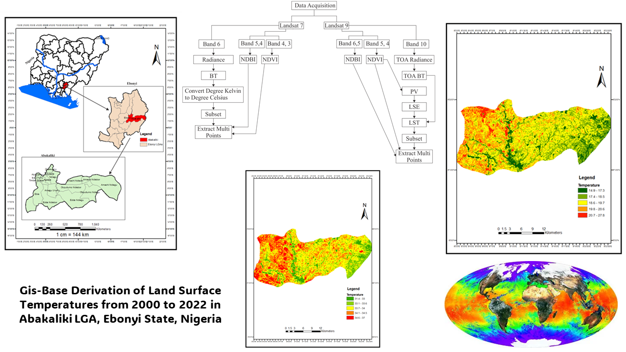
The escalating rise in Land Surface Temperatures poses severe climate risks globally. However, quantifying local warming patterns and associated vulnerabilities remains crucial, particularly in data-scarce regions like sub-Saharan Africa. This study harnesses the power of multi-temporal Landsat thermal imagery, calibrated with gridded meteorological reanalysis, to characterize the shifts in the thermal landscape of Abakaliki, Local Government Area of Ebonyi State, Nigeria, over a two-decade period from 2000 to 2022. The retrieved Land Surface Temperatures were classified into five distinct regimes and compared using zonal statistics, further regressed against climatic drivers. The results unveil a significant surface warming trend, with average temperatures soaring by 15°C and minimum temperatures rising over 16 °C. Notably, the spatial heterogeneity of these impacts is mediated by surface properties, while the compression of inter-annual variability signifies a diminishing thermal resilience. Preliminary regression analysis attributes the primary causality to anthropogenic forcing, exacerbating regional climate shifts, with a robust coefficient of determination (R² = 0.86) and a statistically significant p-value (p < 0.05). Alarmingly, the amplified nocturnal temperatures now persistently exceed hazardous thresholds of 30 °C, posing mounting risks to human health, agriculture, and ecosystems, necessitating adaptive interventions. Furthermore, this observational approach underscores the indispensable role of integrated Earth observations and statistical modeling in characterizing local climate change impacts, mechanisms, and feedback, particularly in areas where in-situ monitoring networks are sparse. Ultimately, the study provides policy-relevant insights into the transformed thermal conditions that resilience strategies must now address to safeguard livelihoods under the rapid climate shifts unfolding across southeastern Nigeria and comparable environments.
References
Chatterjee, S., & Dinda, A. (2022). Determination of characterized urban thermal zones (UTZ) for assessing microclimates in the tropical metropolitan area of Kolkata. Sustainable Cities and Society, 80. https://doi.org/10.1016/j.scs.2022.103807 DOI: https://doi.org/10.1016/j.scs.2022.103807
Masek, J. G., Vermote, E. F., Saleous, N. E., Wolfe, R., Hall, F. G., Huemmrich, K. F., Gao, F., Kutler, J., & Lim, T. K. (2006). A Landsat surface reflectance dataset for North America, 1990-2000. IEEE Geoscience and Remote Sensing Letters, 3(1), 68-72. https://doi.org/10.1109/LGRS.2005.857030 DOI: https://doi.org/10.1109/LGRS.2005.857030
National Bureau of Statistics. (2016). Population census of Nigeria. National Bureau of Statistics. https://nigerianstat.gov.ng/elibrary
National Population Commission. (2022). 2022 projected population figures. National Population Commission. https://www.population.gov.ng/index.php/publication/projected-population
Nigerian Meteorological Agency. (2022). Nigeria: Climate. Nigerian Meteorological Agency. https://nimet.gov.ng/climate/
Nuñez, Y., Hoyos, N., & Arellana, J. (2023). High land surface temperatures (LSTs) disproportionately affect vulnerable socioeconomic groups in Barranquilla, Colombia. Urban Climate, 52. https://doi.org/10.1016/j.uclim.2023.101757 DOI: https://doi.org/10.1016/j.uclim.2023.101757
Nwafor, J. C. (2006). Environmental impact of rural-urban migration into Onitsha urban area of Anambra State, Nigeria. Journal of Human Ecology, 19(1), 63-69. https://doi.org/10.1080/09709274.2006.11905852 DOI: https://doi.org/10.1080/09709274.2006.11905852
Nwafor, J. C., Okoye, C. O., & Enete, I. C. (2018). Drivers and consequences of rural-urban transformation of Abakaliki, Southeast Nigeria. Applied Geography, 90, 192-204. https://doi.org/10.1016/j.apgeog.2017.11.004 DOI: https://doi.org/10.1016/j.apgeog.2017.11.004
Rao, P., Tassinari, P., & Torreggiani, D. (2023). Exploring the land-use urban heat island nexus under climate change conditions using machine learning approach: A spatio-temporal analysis of remotely sensed data. Heliyon, 9(8). https://doi.org/10.1016/j.heliyon.2023.e18423 DOI: https://doi.org/10.1016/j.heliyon.2023.e18423
Terence, D.M., Onisimo, M. & John O. (2022). Estimating urban LST using multiple remotely sensed spectral indices and elevation retrievals. Sustainable Cities and Society, 78,103623. https://doi.org/10.1016/j.scs.2021.103623. DOI: https://doi.org/10.1016/j.scs.2021.103623
Tonolli, S., Leo, L. S., Medinilla, P., Lopinto, E., & Pirotti, F. (2011). Continuous monitoring of thermal anomalies on MODIS and ASTER images using an efficient partial unmixing approach. Remote Sensing, 3(12), 2676-2694. http://dx.doi.org/10.1016/j.jvolgeores.2012.04.022 DOI: https://doi.org/10.1016/j.jvolgeores.2012.04.022
Weng, Q., Lu, D., & Schubring, J. (2004). Estimation of land surface temperature-vegetation abundance relationship for urban heat island studies. Remote sensing of environment, 89(4), 467-483. https://doi.org/10.1016/j.rse.2003.11.005 DOI: https://doi.org/10.1016/j.rse.2003.11.005
Downloads
Published
How to Cite
Issue
Section
License
Copyright (c) 2024 Francis Ezinwannediuto Onuegbu

This work is licensed under a Creative Commons Attribution 4.0 International License.
Authors who publish with this journal agree to the following terms:
1) Authors retain copyright and grant the journal right of first publication with the work simultaneously licensed under a Creative Commons Attribution License that allows others to share the work with an acknowledgement of the work's authorship and initial publication in this journal.
2) Authors are able to enter into separate, additional contractual arrangements for the non-exclusive distribution of the journal's published version of the work (e.g., post it to an institutional repository or publish it in a book), with an acknowledgement of its initial publication in this journal.
3) Authors are permitted and encouraged to post their work online (e.g., in institutional repositories or on their website) prior to and during the submission process, as it can lead to productive exchanges, as well as earlier and greater citation of published work.