
Determination of height in corn (Zea mays L.) crops through the use of images produced by UAVs
DOI:
https://doi.org/10.14295/bjs.v3i3.519Keywords:
Zea mays, remote sensing, precision agriculture, droneAbstract
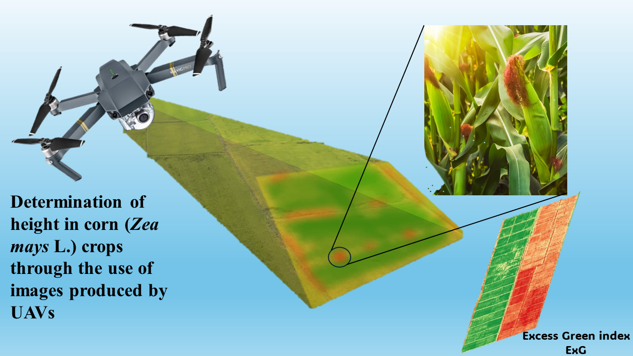
Behind only soybean production, corn is the second most produced grain in Brazil. Remote sensing is generally considered one of the most important technologies for precision agriculture and smart agriculture, enabling producers to monitor various parameters in agricultural crops. This work aimed to determine the height of plants in corn crops through the photogrammetry technique using unmanned aerial vehicles (UAVs). The experiment was conducted in the municipality of Montividiu, State of Goiás, Brazil, in the 2023 harvest. The mapped crop was corn, the georeferenced images were captured via drone, with 249 photos generated during approximately 14 min of flight. The geoprocessing of the orthomosaic and digital surface model was ArcGIS, in which the sketch was plotted on the orthophoto (georeferenced image) to later extract the height data for each treatment. The original data were subjected to the normality test with 5% significance and homogeneity test with 5% significance, then the data were subjected to analysis of variance using the F test with p < 0.05 and, when significant, it was used if the Tukey test with p < 0.05. Block A had the best performance for average plant height with values above 0.8 m. The use of UAVs proved to be an important and efficient tool in determining the height of corn plants for future work on phytopathology, nutrient deficits, areas with leaching or even distinguishing different cultivars.
References
Box, G. E. P., & Cox, D. R. (1964). An analysis of transformations. Journal of the Royal Statistical Society. Series B (Methodological), 26(2), 211-252. https://doi.org/10.1111/j.2517-6161.1964.tb00553.x DOI: https://doi.org/10.1111/j.2517-6161.1964.tb00553.x
Bruin, J., & Pedersen, P. (2004). Early season scouting; extension and outreach. IC-492:7; Iowa State University: Ames, IA, USA, 33-34.
Climatempo. Climatologia e histórico de previsão do tempo em Montividiu, BR. Available in: https://www.climatempo.com.br/climatologia/2740/montividiu-go. Access in November 08, 2023.
Conab. (2022). Companhia Nacional De Abastecimento. Acompanhamento da safra brasileira – Grãos: safra 2021/2022. 12º Levantamento, 9(12), 51 p.
Conab. (2023). Companhia Nacional De Abastecimento. Acompanhamento da safra brasileira – Grãos: safra 2022/2023. 12ª Levantamento, 10(12), 58 p.
Cruz, C. B. M., Barros, R. S., Cardoso, F. V., Reis, F. B., Rosário, L. S., Barbosa, S. S, Rabaco, L. M. L., & Lourenço, J. S. Q. (2011). Avaliação da exatidão planialtimétrica dos modelos digitais de superfície (MDS) e do terreno (MDT) obtidos através do LIDAR. In: Anais XV Simpósio Brasileiro de Sensoriamento Remoto - SBSR, Curitiba: INPE, 5463 p.
Ferraz, M. A. J., Pereira, J. L. A. R., Ferraz, G. A. J., & Santos, N. L. R. C. (2022). Determinação de altura de plantas de milho através da análise de imagens aéreas obtidas com ARP. Brazilian Journal of Development, 8(1), 6900-6917. https://doi.org/10.34117/bjdv8n1-465 DOI: https://doi.org/10.34117/bjdv8n1-465
Ferreira, E. B., Cavalcanti, P. P., & Nogueira, D. A. (2014). ExpDes: An R Package for ANOVA and Experimental Designs. Applied Mathematics, 05(19), 2952-2958. https://www.scirp.org/html/4-7402250_51204.htm DOI: https://doi.org/10.4236/am.2014.519280
Fitz, P. R. (2008). Geoprocessamento sem compilação. São Paulo: Oficina de Texto.
García-Martínez, H., Flores-Magdaleno, H., Ascencio-Hernández, R., Khalil-Gardezi, A., Tijerina-Chávez, L., Mancilla-Villa, O. R., & Vázquez-Peña, M. A. (2020). Corn Grain Yield Estimation from Vegetation Indices, Canopy Cover, Plant Density, and a Neural Network Using Multispectral and RGB Images Acquired with Unmanned Aerial Vehicles. Agriculture (Switzerland), 10(277). https://doi.org/10.3390/agriculture10070277 DOI: https://doi.org/10.3390/agriculture10070277
Henrique, I. G., Bosqueiro, R. O., Kotsubo, R. M., & Botelho, S. C. C. (2021). Déficit hídrico e a germinação de sementes de híbridos de milho. Nativa, 9(3), 240-246. https://doi.org/10.31413/nativa.v9i3.9686 DOI: https://doi.org/10.31413/nativa.v9i3.9686
Liu, T. D. J., Shanga, J., Ma, B. Q. B., Kovacs, J. M., Waltersb, D., Jiao, X., Genga, X., & Shia, Y. (2019). Assessment of red-edge vegetation indices for crop leaf area index estimation. Remote Sensing of Environment, 222, 133-143. https://doi.org/10.1016/j.rse.2018.12.032 DOI: https://doi.org/10.1016/j.rse.2018.12.032
Lopes, J. R. F., Dantas, M. P., & Ferreira, F. E. P. (2019). Variabilidade da precipitação pluvial e produtividade do milho no semiárido brasileiro através da análise multivariada. Nativa, 7(1), 77-83. https://doi.org/10.31413/nativa.v7i1.6243 DOI: https://doi.org/10.31413/nativa.v7i1.6243
Nakarmi, A. D., & Tang, L. (2014). Within-row spacing sensing of maize plants using 3D computer vision. Biosystems Engeenering, 125, 54-64. https://doi.org/10.1016/j.biosystemseng.2014.07.001 DOI: https://doi.org/10.1016/j.biosystemseng.2014.07.001
Nascimento, R. T., Pavan, B. E., Guerra, E. D., & Lima, F. N. (2014). Seleção em variedades de milho crioulo no sul do Piauí. Nativa, 2(2), 114-118. https://doi.org/10.31413/nativa.v2i2.1500 DOI: https://doi.org/10.14583/2318-7670.v02n02a09
Neto, E. V. L., Silva, A. V., Silva, J. H. B., Silva, C. M., Costa, T. R. S., & Mielezrski, F. (2023). Índices espectrais de vegetação no monitoramento do milho (Zea mays L.) submetidos à bioestimulantes. Nativa, 11(3), 323-330. https://doi.org/10.31413/nat.v11i3.13779 DOI: https://doi.org/10.31413/nat.v11i3.13779
Olson, D., Chatterjee, A, Franzen, D. W., & Day, S. S. (2019). Relationship of drone-based vegetation indices with corn and sugarbeet yields. Soil Fertility and Crop Nutrition, 111(5), 2545-2557. https://doi.org/10.2134/agronj2019.04.0260 DOI: https://doi.org/10.2134/agronj2019.04.0260
Passos, E. G. C, Xavier, A. R., Neves, L. O., Masiero, F. C., & Araújo, J. C. (2019). Uso de imagens aéreas obtidas por drone no monitoramento do desenvolvimento da cultura do milho. In: XII MICTI e VI IFcultura.
Pereira, C. S., Giese, E., Fiorini, I. V. A., & Lange, A. (2018). Épocas de semeadura de milho na região norte de Mato Grosso. Nativa, 6(3), 241-245. https://doi.org/10.31413/nativa.v6i3.5471 DOI: https://doi.org/10.31413/nativa.v6i3.5471
Pessi, D. D., José, J. V., Mioto, C. L., & Silva, N. M. (2020). Aeronave remotamente pilotada de baixo custo no estudo de plantas invasoras em áreas de cerrado. Nativa, 8(1), 66-80. https://doi.org/10.31413/nativa.v8i1.8433 DOI: https://doi.org/10.31413/nativa.v8i1.8433
Team, R. D. C. (2018). A Language and Environment for Statistical Computing, R Foundation for Statistical Computing, Vienna, Austria. Available online at https://www.r-project.org/
Tsouros, D.C., Bibi, S., & Sarigiannidis, P. (2019). A review on uav-based applications for precision agriculture. Information, 10(349), 1-26. https://doi.org/10.3390/info10110349 DOI: https://doi.org/10.3390/info10110349
Varela, S., Dhodda, P. R., Hsu, W. H., Vara Prasad, P. V., Assefa, Y., Peralta, N. R., Griffin, T., Sharda, A., Ferguson, A., & Ciampitti, I. A. (2018). Early-season stand count determination in corn via integration of imagery from unmanned aerial systems (UAS) and supervised learning techniques. Remote Sensing, 10(343), 1-14. https://doi:10.3390/rs10020343 DOI: https://doi.org/10.3390/rs10020343
Downloads
Published
How to Cite
Issue
Section
License
Copyright (c) 2024 Jefferson Peres de Oliveira, André Luiz Ferreira Oliveira, Hugo Manoel de Souza, Igor Vinícius dos Santos Araújo, Daniel Noe Coaguila Nuñez

This work is licensed under a Creative Commons Attribution 4.0 International License.
Authors who publish with this journal agree to the following terms:
1) Authors retain copyright and grant the journal right of first publication with the work simultaneously licensed under a Creative Commons Attribution License that allows others to share the work with an acknowledgement of the work's authorship and initial publication in this journal.
2) Authors are able to enter into separate, additional contractual arrangements for the non-exclusive distribution of the journal's published version of the work (e.g., post it to an institutional repository or publish it in a book), with an acknowledgement of its initial publication in this journal.
3) Authors are permitted and encouraged to post their work online (e.g., in institutional repositories or on their website) prior to and during the submission process, as it can lead to productive exchanges, as well as earlier and greater citation of published work.